Sunday, 25 November 2012

London’s Railways– a future where the snail belongs in the garden, and eating sardines does not remind us of the Northern Line


INTRODUCTION
The scene below will be familiar to many of us:

(copyright, Getty Images)

It’s a full and standing deep tube train. It takes ages for the people to get off, and there’s a chance you won’t get on. When you do get on, you have no personal space, so heaven help you if the person next to you is playing loud music or wearing strong perfume. In short, NO FUN.

So what’s the alternative?

Well, you could go and live in an isolated farm in the country like this:


But if we all did that, the countryside would soon look like this:


(copyright citytransport.info)

So it’s probably a good idea to build a lot of these instead:


(copyright Wikipedia)

And to a certain extent that is what we are doing. But I worry about whether our plans are strategic, or whether we are simply leaving the issues for our grandchildren to solve.

WHY THE LONDON TERMINI ARE WHERE THEY ARE

In the 1830s, Isambard Kingdom Brunel invented the railway. Not true, but he and many others sought to bring the railways to north and west London from far afield. But the railway had a point at which it could not penetrate: the New Road, what is now Old Marylebone Road, Marylebone Road, Euston Road and Pentonville Road. This was a bypass to Oxford Street and High Holborn built across fields in the late 18th century. Just as today, people had built as far as the bypass, so there was no way further into the city. A Royal Commission was set up basically preventing the building of railways in the area shaded red below:


What about going underground, you say? If you had had that idea in the 1830s, you might have been rich, as the world's first underground railway didn't open until 1863 - as it happens, underneath the New Road. So that's why the termini are where they are.

TERMINI – WHO NEEDS THEM? AND WHO DOESN’T?

In the 19th century, the termini were ‘cathedrals of steam’: they showed the companies who owned them as great entrepreneurs. Today, they act as the entry and exit points of the visitor, and there is some fantastic architecture to be seen, of which there are two examples below:


St Pancras Station, copyright BBC


The Shard from London Bridge Station

But to the daily commuter, the termini are more often than not an inconvenience: if they are heading for the City, the West End or Canary Wharf, they will need to catch another train unless they are coming into Cannon Street, Liverpool Street, Fenchurch Street or perhaps London Bridge, for the City, or Charing Cross for the West End. And remember that the daily commuter can come from as far afield as Bristol or Norwich. People in a hurry don’t want to be left at a crowded station a long way from their next train.

DIFFERENT TYPES OF TRAIN IN LONDON

Simplistically, there are three types of train:


  1.  urban trains operating solely within the M25:

        Northern Line train, copyright Wikipedia
  2. metro trains operating to 25 or so miles beyond the M25:


    Thameslink train, copyright Wikipedia

  3. long distance trains.

East Coast Main Line train, copyright Wikipedia


I will make three assumptions now, to which I will refer in the rest of this article:

  1. It’s a good idea to take long distance trains to termini, as this gives visitors a good impression of the capital. They also spend money there, in the same way people do at airports;
  2. Urban trains will see only small changes in the next 50 years (such as the proposed Metropolitan extension to Watford Junction);
  3.  Metro trains will see large increases in capacity in the next 50 years, as it is here that we can reduce the crowding on the urban trains, and create capacity at termini for long distance trains by diverting metro trains.

I will also set two related objectives:
  1. Passengers on metro trains should not need to change at a traditional terminus: their journey should take them directly to at least one of the West End, the City and Canary Wharf;
  2. Passengers on long-distance trains should be able to change at a distributor station to allow them to continue their journey on an urban or a metro train which would take them directly to at least one of the West End, the City and Canary Wharf.


WHERE WOULD DISTRIBUTOR STATIONS BE SITED?

For each terminus, I’ve looked at possibilities for a related distributor station for current long-distance services. The output is shown below:

Terminus
Distributor station
King’s Cross
Finsbury Park
St. Pancras
West Hampstead
Euston
None
Marylebone
None
Paddington
Ealing Broadway
Liverpool Street
Stratford
London Bridge/Cannon Street/Charing Cross
None
Victoria
None
Waterloo
None
Fenchurch Street
None

Looking at current expansion plans, amending them and adding in some of my own (and of others), I end up with this:

Terminus
Distributor station
King’s Cross
Finsbury Park
St. Pancras
West Hampstead/Mill Hill East
Euston
Watford Junction
Marylebone
West Hampstead
Paddington
Old Oak Common
Liverpool Street
Stratford
London Bridge/Cannon Street/Charing Cross
New Den
Victoria
Clapham Junction
Waterloo
Clapham Junction
Fenchurch Street
Limehouse

 LET'S START FROM NEXT MONTH'S TIMETABLE

Why not now? Well, next month gives us an extension of the East London Line to Clapham Junction (the bit in dark blue on the map below), and two urban trains per hour will no longer terminate at London Bridge:

So the metro and urban trains arrivals at the main line termini at peak look like this:

Terminus
Metro and urban peak hour terminating trains
King’s Cross
11
St. Pancras
0
Euston
11
Marylebone
4
Paddington
10
Liverpool Street
37
Charing Cross
15
Cannon Street
11
Victoria
23
Waterloo
33
Fenchurch Street
19
London Bridge
21
Moorgate
12

I've added in Moorgate to the list of termini above for reasons which will become clear later. But one fact is immediately obvious: there are a lot more metro and urban trains in the south and east than in the north and west (thanks to Stephen Colebourne for pointing this out). This must direct our plans to create more capacity.

COMMITTED IMPROVEMENTS 1 - THAMESLINK

The Thameslink Programme takes a line between London Bridge and King's Cross, and puts 24 trains per hour on it by 2018. The line exists now, but cannot operate at peak hours largely because of conflicting movements with trains heading to Charing Cross. Before the work started, the line could support eight trains per hour.

This is the current plan for the Thameslink service pattern:

          No             South of London         North of London  Length Times
1   Brighton semi-fast  Bedford semi-fast 12-car all day
2
3   Brighton stopping  Bedford semi-fast 12-car all day
4
5   Three Bridges via Redhill  Peterborough semi-fast 12-car all day
6
7   Horsham  Cambridge semi-fast 12-car all day
8
9   East Grinstead  Bedford semi-fast 12-car peak only
10
11   Caterham fast north of Norwood Junction  St. Albans stopping 8-car all day
12
13   Tattenham CornerWelwyn Garden    City stopping 8-car all day
14
15   Tunbridge Wells via Tonbridge   Bedford semi-fast 12-car peak only
16
17   Ashford International   Luton semi-fast 12-car peak only
18
19   Maidstone East semi-fast via Catford Welwyn Garden City stopping 8-car all day
20
21   Sevenoaks skip-stop via Catford   Luton stopping 8-car all day
22
23   Bellingham stopping via Catford   St. Albans stopping 8-car all day
24

So what does this do to the urban and metro terminators? Frankly, not as much as one might have hoped: some of the services don't exist today south of the river.

Terminus
Urban and metro peak hour arrivals post Thameslink
Compared to today
King’s Cross
11
-4
St. Pancras
0
0
Euston
11
0
Marylebone
4
0
Paddington
10
0
Liverpool Street
37
0
Charing Cross
13
-2
Cannon Street
7
-4
Victoria
23
0
Waterloo
33
0
Fenchurch Street
19
0
London Bridge
16
-5
Moorgate
8
-4

But a couple of things:

1) There's no benefit in reducing capacity at Cannon Street or Charing Cross, so it makes sense to switch a few London Bridge terminators there.

2) There's a project to expand the capacity between Alexandra Palace and Finsbury Park. So Moorgate's capacity won't actually change after Thameslink comes on line. So a better position is this:


Terminus
Urban and metro peak hour arrivals post Thameslink
Compared to today
King’s Cross
11
-4
St. Pancras
0
0
Euston
11
0
Marylebone
4
0
Paddington
10
0
Liverpool Street
37
0
Charing Cross
15
0
Cannon Street
11
0
Victoria
23
0
Waterloo
33
0
Fenchurch Street
19
0
London Bridge
10
-11
Moorgate
12
0


COMMITTED IMPROVEMENTS 2 - CROSSRAIL 1

Crossrail 1 is a another project due to deliver in 2018. It will link east and west London via a tunnel from Royal Oak (west of Paddington) to east of Whitechapel in the East End. The route map is shown below:

(image courtesy Wikipedia)

The objectives are multiple:

1) To give a direct route from Heathrow to the West End, the City and Canary Wharf;
2) To bring a further 1.5m people within 45 minutes' commuting distance of the central business districts above;
3) To relieve pressure on the Circle, Hammersmith & City and Central Lines.

For a start, let's look at the planned opening service pattern (or the best I can surmise):

West London
East London
Number of trains per hour
Paddington
Abbey Wood
7
Paddington
Shenfield
7
Heathrow
Abbey Wood
3
Heathrow
Shenfield
3
Maidenhead
Abbey Wood
2
Maidenhead
Shenfield
2

This may create good finance for a project, but it doesn't make sense for a number of reasons:

1) If you terminate the trains at Maidenhead, where do you put the western depot? And how do you deal with the fact that more people travel west in the morning peak than east? Terminate eastbound trains here also?
2) This terminates 14 trains at Paddington, which could euphemistically be described as "somewhat wasteful"
3) The termination of 12 trains at Abbey Wood does not make sense when a service from Gravesend could be taken over.

Added to this one can easily see the service to Canary Wharf running at capacity from day one. So let's in the first place follow the plan of the Route Utilisation Strategy (RUS):

1) extend to Reading (which probably saves money once the Great Western wiring is complete);
2) increase the Heathrow capacity to ten trains per hour;
3) move ten metro trains per hour from terminating at Euston to running across Crossrail by building a link west of Paddington.

Let's add in the RUS-suggested idea of extending to Gravesend, and we can take over four more trains per hour in the east - but this mean Crossrail having its own tracks, as the alternative would be to adapt Crossrail's trsins to run on third rail traction, which seems to be retrograde. The pattern we could end up with is:


West of London
East London
Number of trains per hour
Watford Junction + beyond
Abbey Wood
3
Watford Junction + beyond
Gravesend
2
Watford Junction + beyond
Shenfield
5
Heathrow
Abbey Wood
3
Heathrow
Gravesend
2
Heathrow
Shenfield
5
Reading
Abbey Wood
2
Reading
Shenfield
2
So what does this do to the metro and urban terminators? Again, moving the lost Cannon Street and Charing Cross terminators from London Bridge, we see this:

Terminus
Urban and metro peak hour arrivals post Thameslink & Crossrail 1
Compared to today
King’s Cross
11
-4
St. Pancras
0
0
Euston
1
-10
Marylebone
4
0
Paddington
0
-10
Liverpool Street
25
-12
Charing Cross
15
0
Cannon Street
11
0
Victoria
23
0
Waterloo
33
0
Fenchurch Street
19
0
London Bridge
6
-15
Moorgate
12
0


One of the reasons for moving the Euston urban and metro services to Crossrail 1 is to allow High Speed Two to arrive at a redeveloped Euston. But the metro services used to run via the Bakerloo line to Watford Junction, as shown below in this poster from RetroRail::


And, of course, they could again. If we were to move metro Chiltern services from Wycombe to Marylebone on to Crossrail 1 this would allow a potential expansion of long distance services into Marylebone - but that's the subject of another article. For now, let's give the final legacy of Crossrail 1 as below:

Terminus
Urban and metro peak hour arrivals post Thameslink & Crossrail 1
Compared to today
King’s Cross
11
-4
St. Pancras
0
0
Euston
0
-11
Marylebone
0
-4
Paddington
0
-10
Liverpool Street
25
-12
Charing Cross
15
0
Cannon Street
11
0
Victoria
23
0
Waterloo
33
0
Fenchurch Street
19
0
London Bridge
6
-15
Moorgate
12
0


FUTURE PROJECTS - CROSSRAIL 2

Crossrail 2 is a plan for a line from south-west London to north-west London. It started life as a Tube line relieving the District Line, the Central Line and the Victoria Line:

(image seen on beleben.wordpress.com)

While many commentators like this route, there are obvious failings:
  1. It doesn't call at Euston, where HS2 will arrive in 2026 and potentially cause peak-hour crowding;
  2. It does nothing (or very little) to alleviate crowding at the three stations with most terminating metro trains (in 2018 as now): Liverpool Street, Waterloo and Victoria.
So the favoured route is now this:

(image courtesy TfL)

My first reaction is to be a little bewildered. While this proposal will clearly help Waterloo and the Victoria Line, Victoria itself and Liverpool Street aren't helped much. And what on earth is happening at the north end? Hertford East to Liverpool Street has two trains an hour in the peak. Even extending all Cheshunt trains to Hertford East that's only six trains per hour. So do we terminate 18 trains an hour at Alexandra Palace? One thing we must not do is take over Moorgate trains: in the peak on the Welwyn Garden City trains, there are more people on Moorgate metros than King's Cross metros, so it would not be a popular move to create an Alexandra Palace to Moorgate metro. My belief is that this design is the outcome from someone being given a limited budget. I will come back to Crossrail 2 after looking a little more strategically at Canary Wharf.

CANARY WHARF - PLANNING FOR THE FUTURE

According to Wikipedia, around 90,000 people work in Canary Wharf, as opposed to around 315,000 in the City. But with 540 extra floors of office space in tall buildings planned for 2019, the 90,000 figure could double. Let's look at train capacity today:


Now there are a couple of invalid assumptions here:

1) Not all people on a train alight at Canary Wharf;
2) A number of people going to Canary Wharf arrive by bus, foot or bicycle.

However, when I overlay the 2019 position, the illustration becomes clear:


Despite providing all the extra capacity Crossrail 1 gives us (along with all the DLR trains being 3 car, and the Jubilee Line running 32 trains per hour in each direction), it takes longer for everyone to arrive at work. The answer is relatively simple in theory - 24 trains per hour on Crossrail 1:


THE NORTHERN CITY LINE

When I talk of the Northern City Line, I mean this part of the First Capital Connect Network:

(image courtesy First Capital Connect)

As explained previously, this runs 12 trains an hour at peak into Moorgate. This is split across the Welwyn Garden City and Hertford North routes, with some Hertford North traffic going to and from Letchworth. The 6-car trains are full and standing as far as Old Street in the peak, thereafter merely full.

While people are being carried to the City, many will be continuing their journeys to Canary Wharf, particularly with jobs having been moved from the City to Canary Wharf over the years and people not moving house. There is also the point that the line from New Barnet southwards is less than a mile to the east of the High Barnet branch of the Northern Line, so either line can appeal to tens of thousands of people. Extending this line to meet the south-eastern branch of Crossrail 1 can relieve the Northern Line, and create the capacity Canary Wharf will lack by 2019.

One rather immediate issue as you start to tunnel beyond Moorgate on the Northern City Line is that Crossrail 1 is immediately behind the end of the line. But that's not an issue, as the Crossrail station is double ended (at Moorgate/Liverpool Street) so moving the Northern City Line further east gives an interchange to National Rail, Crossrail 1,  and the Northern, Central, Circle, Metropolitan and Hammersmith & City Underground lines. From there it is probably easiest to four track Crossrail 1 to Whitechapel. One new station at Moorgate/Liverpool Street, one expanded station at Whitechapel. Three miles of tunnel - plus the work to make from Drayton Park to Moorgate suitable for longer trains - and a fantastic benefit is achieved. It  doesn't move any trains out of termini, but it does mean we need to rework Crossrail 2.

* Many thanks to Lemmo whose idea it was to expand the Northern City Line to Canary Wharf.

Saturday, 6 October 2012

Five tracks into Waterloo?

I read with interest the plan in Modern Railways to run - at an unspecified time in the future - five tracks from Surbiton to Waterloo. This allows for 32 fast trains per hour (tph) in the peak - and not only that, the train lengths can expand to 12 car (even though the current plan is only to 10 car). So overall, that's a capacity increase from 8 car to 10 car, and 24tph to 32tph. 67% more capacity on fast trains. Waterloo's capacity issues solved, right?

WRONG. What will we do with all the people once they reach Waterloo? I'm minded (with apologies to Ray Davies) to think "whenever I gaze on Waterloo Sunset, I can't see it for all the perishing commuters". If all the said commuters worked on the South Bank or the Old Vic there wouldn't be an issue, but many of the them are heading for the City (via the Drain), Canary Wharf (via the Jubilee Line) and the West End (via the Northern Line).

So if the people don't want to go to Waterloo, why take them to Waterloo?

Firstly a bit of history. If we had a clean sheet and we were building railway stations in London for the first time, we'd probably do things very differently. When the railway reached Waterloo in 1848, this was intended as an interim terminus before the railway reached the City. This has never happened in the intervening 164 years. Let's hope we don't have to wait another 164 years before we take people where they want to go.

In defence of the early railway companies, the first underground railway from Baker Street to Farringdon only opened 15 years later in 1863, so the thought of transporting people from Waterloo across a crowded London to the City was perhaps a little optimistic. Along what is now the Ring Road or the A501, we see a lot of terminals which are not where the commuters want to go. This is a legacy of the early Victorians being innovative in bringing their railways to London, but being restricted by the technology available at the time to the Ring Road.

So in 2012 does it make sense to bring more people to where they don't want to be? Of course not!

Maybe I'm being a little harsh

Or maybe not. Next paragraph.

Regional express versus regional metro

In the original proposal for Crossrail, the benefits of running trains from far afield through an East-West tunnel was assessed compared to trains from the London suburbs. The result was a higher benefit to cost ratio on the regional metro, which is why we are building Crossrail 1 as a fast all stops service. But even though it may open that way, there is nothing stopping us running a Swansea to Norwich service through the tunnels in the future. To anyone changing at Paddington, it's a train across town like any other. For the hordes heading for the West End or The City, it's a train which takes them where they want to go with a walk at the end of their journey. Radical, huh?

We maybe need to think the same way regarding Waterloo. And Victoria and Euston. The tube stations are full. Bringing more people in makes them fuller. You can create more space so that the wait is less unpleasant, but what has been gained overall?

Possible solution

There has to be joined-up strategic thinking. The Victoria Line is full, so Crossrail 2 seems to be the most important London scheme not yet committed. But its current form seems to be looking at regional metro only, as below courtesy TfL. Why would you not run Edinburgh to Southampton or Brighton trains, for example?

 We seem to be forever putting Londoners first, whereas there is a way of satisfying both the regional and the express market. Build the central tunnel as four tracks to Euston. Extend a line from Clapham Junction to join the Brighton Line. Run the fast trains from Manchester and Liverpool to Brighton and Southampton. That way you don't need Crossrail 3 - the objective should be to transport people to Clapham Junction, not Waterloo.

Thoughts welcome.

Saturday, 7 July 2012

Memories of seven years ago

Seven years ago yesterday, I was one of many people in Britain celebrating that the Olympics would be hosted in London in 2012. In those days I was commuting daily except for Thursdays - having one day away a week allowed me to cope with the exhausting five-hour round trip from home to town. Thus it was not unusual for me to be in late...as I was on 7th July 2005. I had a text from my boss at the time just as I was coming into Paddington that there had been a power surge at Aldgate, and the station was closed. Effect, not cause, as I was to find out later.

I arrived at Paddington about 09:20 to find the tube station shut. No explanations, so I just walked. The 205 bus stops outside Paddington and outside where I worked then, as it does now - I have just moved along the Ring Road. But no hopes of catching a 205 that day - it was trying to be the Circle, Hammersmith and City and Bakerloo lines all at once. So I decide to walk.

In those days I had a Nokia phone with a tiny screen, as I'm sure many of you did. I was one of the few able to access the Internet, so I was able to 'confirm' a power surge at Aldgate. I can't have been the only one who wondered why that would close Paddington, six miles away. I wasn't able to walk for long along the 205 route, as it was taped off by the police near Edgware Road station. By this time, I've realised something serious is wrong, and I try to access the BBC. No mobile coverage, a situation which was to remain for hours. So I couldn't tell my boss I would be late.


I've known my way across London since learning maps at about the age of seven, so no problem heading south to Bayswater Road then along Oxford Street towards the City. Anyone with any sense would have turned round and gone home, but for all I knew the high speed trains weren't running either. I realised pretty quickly there were no buses, at which point there were no doubts in my mind what had happened had closed transport in London.


I continued along High Holborn towards St. Paul's, but I didn't get far before the road was taped off. Understandably the police didn't want people heading into the City, and I headed for Clerkenwell and Shoreditch. I thought it would be easy to get into work via Smithfields, but the cordon around Aldgate was huge, and I had to divert half a mile east. Fortunately for me, work was just outside the cordon.


I arrived at work to find out that 52 had perished that day due to the actions of four suicide bombers. Three bombs had been on trains - at Edgware Road, Aldgate and Russell Square - and one on a bus at Tavistock Square. The train bombs had gone off at 8:50am - about the time I would arrive at Aldgate to be at work for 9am. I often wonder how many others thank their lucky stars that their behaviour deviated from the norm that day.


I rang my wife at work, who told me that my mother was frantic. I promptly called her, then my dad - who had been out in the garden and was blissfully unaware. A half-full and rather nervy office then continued with its normal day-to-day work, so different to the day before when we had all been so pleased about the Olympics.


The bombings changed the way we behaved, if only for a short while. On the evening after the bombs, shops sold out of the London A-Z, as people had to walk on the streets they had for so long been driven under on the tube. People smiled at strangers and talked on the tube. Some wore name tags to show they weren't a threat. The message went out load and clear: WE ARE NOT AFRAID.


I want to finish as I started, by talking about the Olympics. In three weeks' time, the greatest sporting event in the world will open in the greatest city in the world. The way that we will have a final victory over those who would want us to be afraid of travelling in London would be to have an incident-free Games. If that means that security is tighter for a while, I'll live with that. To return to how we felt in the aftermath of 7th July 2005 is not an option.

Saturday, 3 March 2012

Some poems

I'm a flying picket, not a poet. But I've written a couple of things which aren't trash. So without further ado here we go:

The Evil Man

The evil man who never cares
He always does what no-one dares
And now he's climbing up the stairs
Oh no that man is back again!

He says he wants to scare you more
You hear his footsteps on the floor
And now he's opened up the door
Oh no that man is back again!

"You nasty man, you're off your head
Go scare another child instead!"
And now he's jumped under the bed
Oh no that man is back again!

A genie with a magic light
Has scared the man, he runs in fright
He's far way, he's out of sight
That man sure won't be back again.


Maybe

Maybe yes and maybe no
Maybe stop and maybe go
Maybe waiting up all night
Maybe giving you a FRIGHT!

Maybe standing in the rain
Maybe going home again
Maybe stop and maybe go
Maybe we will never know

Saturday, 21 January 2012

On HS2 and Euston (part 2)

I wrote about a month ago on this topic, questioning the need to build HS2 from Old Oak Common to Euston (http://crooked-cottage.blogspot.com/2011/12/on-hs2-and-euston.html). However, I'm delighted to see that HS2 phase 1 (London to Birmingham) has been approved. Not so Stop HS2. I saw this banner at West Ruislip on 13 January:


It's time for Stop HS2 to negotiate for benefits (such as a station in Buckinghamshire) and amend the party line. And as they must move on, so shall I.


Firstly, a central area Tube Map courtesy Transport for London (TfL). If you don't know the lines as well as me, you may want to refer to it when you read this article. Waterloo is one station south of Embankment on the Northern and Bakerloo lines (the black and brown ones):


I've seen a fair amount of talk around Euston being full when HS2 arrives. Ken Livingstone has argued that HS2 should go to Waterloo rather than Euston (http://www.london-se1.co.uk/news/view/5156) although it isn't clear whether this proposal involves a 180 degree turn to reuse the former Waterloo International platforms, abandoned when HS1 moved to St Pancras International. I would hope not: one of these platforms is planned to be brought back into use in 2014 (http://en.wikipedia.org/wiki/London_Waterloo_station#Former_international_platforms) and we can easily move from a "Euston is full" to a "Waterloo is full" debate.

In the meantime Boris Johnson has added his argument to the debate. Reading http://www.thisislondon.co.uk/standard-mayor/article-24028968-build-a-new-tube-line-to-cope-with-hs2-crowds.do , Boris is arguing for a "north-south Tube line" to relieve the crowding. Quite what this means I'm not sure. And, as I noted in a comment to my last article, the deputy chairman of TfL is saying that the wait for a Victoria Line train will be 30 minutes by 2033 if nothing is done to alleviate the crowds (http://www.telegraph.co.uk/news/uknews/road-and-rail-transport/8960899/No-space-in-London-stations-for-high-speed-passengers.html ).

In response (see the Telegraph article above), HS2 Ltd. said that the increase to Tube traffic at Euston caused by the first phase of HS2 would be only 2%. These statements cannot all be true, or their must be assumptions which are not stated here. Let's start with some facts. TfL's stats for 2010 (http://www.tfl.gov.uk/tfl/corporate/modesoftransport/tube/performance/default.asp?onload=entryexit ) say that there were 12,790 entries to Euston Tube station in the morning peak on average in 2010. But going back to the Telegraph article above, HS2 Ltd. estimate that HS2 will bring an extra 13,400 people to Euston in the morning peak. Granted some will catch buses, taxis or walk, but that looks like double, not 100%. And that's without any growth prediction. It's certainly a lot more than 2%. What's going on?

To attempt to understand this, I've gone back to the Department for Transport (DfT) economic case for HS2
(http://highspeedrail.dft.gov.uk/sites/highspeedrail.dft.gov.uk/files/hs2-economic-case.pdf). A few paragraphs help us to understand what's going on:

"As a result of HS2, the number of passengers per day using Euston Mainline Station is expected to increase by 32,000. Surveys of current passengers at Euston suggest around 62% of passengers would arrive or depart by London Underground in the three hour morning peak. With HS2 this would mean 5,500 additional passengers using Euston Underground Station in the morning peak period."

"Both the Northern and Victoria lines which stop at Euston are likely to be heavily overcrowded by 2043 even without HS2. Although the introduction of HS2 will add to this pressure, the number of passengers added by HS2 is likely to be relatively small (around 2%) compared to the number of passengers already forecast to be on London Underground services passing through Euston."

So the figure of 13,400 is presumably a total passing through the station, which isn't relevant. I'll work with 5,500 even though the arithmetic is wrong (62% of 13,400 is 8,308). But it's clear that the 2% relates to people passing through Euston - so it includes people already on the Northern and Victoria Lines and not changing. Not much use in determining the crowding on the platforms. And 2% relative to 2043, by which time huge growth is predicted on both the Northern and Victoria lines, is more than a little unhelpful.

The important date, of course, is 2026, when the first phase of HS2 is planned to open. HS2 Ltd. plan to run 11 trains per hour (tph) in the peaks, four terminating at Birmingham and seven continuing further north-west along the classic lines. When HS2 reaches Leeds and Manchester in 2033, there will be 18 tph in total. So we should take the 5,500 figure pro rata: this gives roughly 3,350.

Also, given that actual predictions are difficult to find, let's take the actual figures from 2003 to 2010 and project based on this (source TfL):


So we are looking at a base figure of 20000 as well as the extra 3350 introduced by HS2. In other words, if these figures are correct, we are looking at almost double the numbers entering the tube station in 2026 at the morning peak as there are today, and the 2% figure quoted by HS2 Ltd. is somewhat irrelevant to the scale of overcrowding: the peak is three hours, so we need to find an extra 3800 spaces on the Northern and Victoria lines per hour on (largely southbound) trains that will already be full. This clearly won't work without some mitigation. 

It has been suggested by the high speed rail consultancy Greengauge21 (
http://www.greengauge21.net/wp-content/uploads/Greengauge-21-Additional-submission-to-TSC-Sept-19.pdf) that some of Crossrail's spare Western capacity should be diverted to the West Coast Main Line. The initial plan is to run 24 tph through the central tunnel from Royal Oak to Whitechapel, but to terminate all but 10 of these west of Paddington. I argued in my original article that this wasn't the best use of the Crossrail capacity, and that it would be better to use it to develop the Chiltern Line market. However, it has to be worth examining.


Map of current plan for Crossrail, courtesy www.crossrail.co.uk

If you look at the DfT figure for onward travel from Euston, 38% of passengers arriving at Euston do not travel onwards by Underground. While it is arguable that those arriving from afar by HS2 in the morning peak would be more likely to travel onwards by tube, this would be less likely to apply to suburban traffic. The point I am making is that Euston has a market, and you cannot remove all local trains without causing inconvenience. So let's say that we keep the Watford Junction to Euston service, and divert 7 tph at peak (four from Milton Keynes, three from Tring). That would be about 1,400 people given these services run on four-car trains (http://en.wikipedia.org/wiki/London_Midland#Current_fleet), maybe 1,750 people as trains into London are often full and standing. In any case, it is far short of the footprint created by HS2 in 2026. While this may be a way of allowing the expanded Euston to be built without creating chaos, it seems to be far from ideal.

So what do we need to make this work? Firstly a tunnel to provide a 24 tph service across a central core from north of Euston to south of Waterloo. You run the 7 tph from Tring and Milton Keynes with the 3 tph from Watford Junction through the tunnel. You send them somewhere to the south-west of Waterloo on suburban services. It doesn't matter where: the Thameslink Programme was built with the idea of "we'll sort the service patterns out later". We still don't know for certain where all the trains will be going, but we do know that there will be 24 tph through the central tunnel.

This doesn't cater for the footprint of HS2 either, and arguably it puts more pressure on the Victoria line if done in isolation than moving services on to Crossrail, as you now have an extra 13 tph coming into Euston with potential passengers. However, there is an obvious way around all this which I've not seen suggested. The footprint associated with the redevelopment of Euston is huge, and costly. Yes, the building is hideous, as is much around it, but its removal will not help commuters to arrive at work on time. If it could be curtailed at the current 18 platforms rather than the planned 24, wouldn't that mean that we didn't need to rebuild?

So where do I put the other six platforms? Underneath Waterloo station (and underneath Euston station to prevent service pollution). This way people heading for the City and Canary Wharf can change at Tottenham Court Road for Crossrail, and the numbers changing at Euston are dramatically reduced. Even the numbers heading for the Victoria Line will be reduced, as anyone heading west on the Central Line from Oxford Circus can change at Tottenham Court Road. Whether this is sufficient to avoid the building of a new line from Victoria to Euston to relieve the Victoria Line in the long term is debatable, but it should be enough to move its opening post 2026. And what else have we done here? Created the potential for a high speed link from the North through to East Croydon and Brighton, removing another notorious bottleneck.

Going back to my original article, do I prefer terminating HS2 at Old Oak Common to what I am suggesting here? Probably, because I deliver many of the benefits at less cost. But, unlike Stop HS2, I'm pragmatic. I'm now seeking to obtain the best solution given the decisions made. Stop HS2 would do well to learn from that lesson.

Sunday, 8 January 2012

A pint in the pub at the end of the line

I've invented very few traditions. I've kept some going in the family, like having ham for Christmas breakfast, but I'm struggling to find more than one which is truly, and uniquely, mine. I've occasionally been known not to take the most direct route home after an evening out, but I'm sure I'm not the first person to whom this has happened. My theory which is mine and belongs to me has nothing to do with brontosauruses. It is that you should enjoy a pint in the pub at the end of the line.


Tube Map, courtesy TfL

Yes, it's the London Underground Map. It was drawn by a young draughtsman called Harry Beck and first published in 1932. What's really clever about it is not that it replaces complicated curves with simple straight lines, but that it brings the suburbs which closer to town. A physical tube map would look a bit like this (it's a bit out of date):

Geographically accurate Tube Map, courtesy thedabbler.co.uk

So what that meant is that people were encouraged to go from Central London to the suburbs for leisure: Beck's map made it look like it wasn't that far. London Underground campaigned for people to do so too, with posters such as this one.
"Kew Gardens", 1934 Maurice A. Miles, courtesy London Transport Museum

So where was I? Oh yes, pubs at the end of the line. I've been allured to the countryside via the tube regularly, so it's worth having a pint when there - hence the tradition. Maybe it's a good thing that the tube doesn't go out quite as far as it used to. Until 1936, the Metropolitan Line went all the way to Verney Junction in Buckinghamshire - about 52 miles from Baker Street! But it would have been a journey to an interesting pub - The Verney Arms, now a private house, is shown below:


Verney Arms, courtesy Wikipedia author Ravenseft under the GNU Free Documentation License

But there are many interesting places. Kew doesn't count as it's the penuntimate station on the District Line - but it has a fantastic restaurant in The Glasshouse. Richmond does though, and it has some lovely pubs by the Thames. Here's one of them.


The White Cross, Richmond, courtesy beerintheevening.com

Richmond. Ever wondered why it shares a name with William Hague's constituency in Yorkshire? It used to be called Sheen until Henry VII built a palace there, and named it after the fact that he was Earl of Richmond. The area around the palace also became known as Richmond. But Sheen survives, in the name of East Sheen, to the east of the town. Not to be confused with East Cheam, home of Tony Hancock in Hancock's Half Hour.

But I digress. Epping. No I wasn't swearing. Eastern terminus of the Central Line. (http://www.tenwordwiki.com/epping). And really in Essex (unlike Ilford and Romford which say they are in Essex, but have been part of the greatest city in the world for decades) - and clearly different from most of London from a picture of its High Street.


Epping High Street, courtesy Epping Forest District Council

And here's a pub in Epping which looks interesting...


The Spotted Dog, courtesy ukpubfinder.com

And how many of you have just thought of what's below? With one final change of subject, cheers!


The Woodentops, BBC, via YouTube standard license.

Sunday, 1 January 2012

Walking to Totteridge

Totteridge. Sounds like a place name Ken Dodd made up. It has an ordinary (but listed) Northern Line station at Totteridge and Whetstone, one stop south of the terminus at High Barnet. Totteridge and Whetstone are separated by the Dollis Brook, which sounds to me like it ought to be the name of an actress from the 1930s.


Totteridge and Whetstone station. Picture courtesy TfL.


Whetstone High Street is a few hundred metres up the hill from the station. Correctly High Road, as this is the old Great North Road. A very ordinary London suburb.


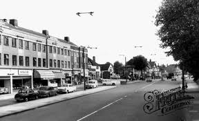
Whetstone High Road in the 1950s. Picture courtesy Francis Frith http://www.francisfrith.com/whetstone,greater-london/photos/high-road-c1955_w480016/

I've known since I've been about six that the A5109 goes from Watling Street at Edgware, crosses the A1 at Apex Corner, then goes through Totteridge to the Great North Road at Whetstone. This came from years of studying 'the big book' - my beloved grandfather's AA Road Atlas of England and Wales.

Like many places just off the routes we used to travel, I always wanted to go to Totteridge. Similarly Dragonby and Pilham in Lincolnshire. With those places I was disappointed when I eventually went. Not so Totteridge.

It was totally by accident that I actually went to Totteridge. I had a phase during the spring of walking from my current customer site near Old Street station to my hotel in Whetstone. It's about nine miles as the crow flies, and the objective was to walk past as many tube stations as possible. Anal I know, but it gives a sense of what London is really like above ground. Did you know for instance that if you walk from London Bridge to Whetstone along the Great North Road you have passed a station of every tube line except the Bakerloo? Did you want to know? I'll move on.

My walk one day took me along the Euston and Marylebone Roads to Baker Street, then north along the Finchley Road past Lord's Cricket Ground to Swiss Cottage (one of three London tube stations named after pubs, the others being Elephant & Castle and Royal Oak).

Ye Olde Swiss Cottage. Courtesy Wikipedia author Oxyman under the GNU Free Documentation License

Then to the innovatively named Finchley Road - you might as well call the station A41, it would be as descriptive as to where you are - and eventually off the main road to Golders Green. Here I did something rather strange: I turned left rather than continue straight on to North Finchley and Whetstone. No idea why, but a good decision. I then seemed to walk forever, crossing the North Circular and eventually ending up at Mill Hill East station, the one stop spur of the Northern Line from Finchley Central. By this time my phone battery was dead so I was following instinct. The area was becoming more and more upmarket: I'd associated the name 'Mill Hill' with the area around Mill Hill Circus on the A1 - curved London buildings, standrard suburbia - not at all like the area I was seeing.

 Mill Hill Circus. Courtesy Martin Addison on Flickr under the Creative Commons License.

Mill Hill School, which I passed on The Ridgeway, is a little grander. To say the least. Unsurprisingly it's hired out for weddings.

Mill Hill School, courtesy Mill Hill School Enterprises.

The road kept going upwards (the clue is in the name - The Ridgeway) until it reached the A5109. Almost home I thought. Actually four miles, as I was much further west than I imagined. Then - hang on - this is ceasing to be suburban, as there are very few houses. We're still climbing, and there's no footpath. And sheep. And those houses that were there were ENORMOUS. Totteridge Common, Barnet's very own Beverly Hills. Montebello, shown below was designed by the architect Philip Jebb - there are properties similar to this along both sides of a two mile stretch of road.


Montebello, Totteridge Common, courtesy www.philipjebb.com

After what seemed forever - by this point I was tired, and it was 1 am - the road headed downwards into Totteridge Village, and the houses became closer together and Mill Hill posh, not the sort of opulence that I'd just left behind. I saw a police car, stationary in the village, and hoped I wouldn't be arrested for walking. But no, this wasn't the real Beverley Hills, so I was fine.

I proceeded down the steep hill to the familiarity of the Dollis Brook and Totteridge and Whetstone tube station. It had been quite an adventure.